
ไฟล์:Myanmar civil war.svg

ขนาดของตัวอย่าง PNG นี้ของไฟล์ SVG นี้: 367 × 599 พิกเซล ความละเอียดอื่น: 147 × 240 พิกเซล | 294 × 480 พิกเซล | 471 × 768 พิกเซล | 628 × 1,024 พิกเซล | 1,255 × 2,048 พิกเซล | 1,228 × 2,003 พิกเซล
ดูภาพที่มีความละเอียดสูงกว่า ((ไฟล์ SVG, 1,228 × 2,003 พิกเซล, ขนาดไฟล์: 1.3 เมกะไบต์))
| รูปภาพหรือไฟล์เสียงนี้ ต้นฉบับอยู่ที่ คอมมอนส์ รายละเอียดด้านล่าง เป็นข้อความที่แสดงผลจาก ไฟล์ต้นฉบับในคอมมอนส์
|

|
This file may be updated to reflect new information. If you wish to use a specific version of the file without new updates being mirrored, please upload the required version as a separate file. |
ความย่อ
| คำอธิบาย |
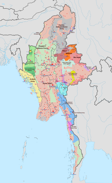
English: A map of the Myanmar civil war (2021–present)
|
| วันที่ | |
| แหล่งที่มา | งานของตัว derivate of Myanmar adm location map.svg โดย NordNordWest. Citing @ThomasVLinge |
| ผู้สร้างสรรค์ | Ecrusized |
| เวอร์ชันอื่น |
|

ไฟล์นี้แปลโดยใช้แท็ก SVG ในการนำไฟล์นี้ไปใช้ในภาษาของคุณ (ถ้าพร้อมใชังาน) กรุณาใช้พารามิเตอร์ ในการแปลไฟล์นี้ไปเป็นภาษาของคุณ ลองใช้งานเครื่องมือแปลภาษา SVG หรืออีกวิธีโดยโหลดไฟล์ไปที่คอมพิวเตอร์ เพิ่มการแปลของคุณโดยใช้เครื่องมือที่คุณคุ้นชิน และอัพโหลดกลับอีกครั้งด้วยชื่อไฟล์เดียวกัน ถ้าไม่แน่ใจว่คุณควรจะทำเช่นไร ไปที่หน้าความช่วยเหลือที่กราฟิกแล็บ |
การอนุญาตใช้สิทธิ
ข้าพเจ้า ในฐานะผู้ถือลิขสิทธิ์ของภาพหรือสื่อนี้ อนุญาตให้ใช้ภาพหรือสื่อนี้ภายใต้เงื่อนไขต่อไปนี้
| ไฟล์นี้มีให้ใช้ภายใต้ CC0 1.0 Universal Public Domain Dedication ของครีเอทีฟคอมมอนส์ | |
| The person who associated a work with this deed has dedicated the work to the public domain by waiving all of their rights to the work worldwide under copyright law, including all related and neighboring rights, to the extent allowed by law. You can copy, modify, distribute and perform the work, even for commercial purposes, all without asking permission.
|
ประวัติไฟล์
คลิกวันที่/เวลาเพื่อดูไฟล์ที่ปรากฏในขณะนั้น
| วันที่/เวลา | รูปย่อ | ขนาด | ผู้ใช้ | ความเห็น | |
|---|---|---|---|---|---|
| ปัจจุบัน | 17:32, 30 เมษายน 2567 | | 1,228 × 2,003 (1.3 เมกะไบต์) | MrBLOCKiron | Continuation of yesterdays edit, check april 29 discussion. |
| 23:45, 29 เมษายน 2567 |  | 1,228 × 2,003 (1.3 เมกะไบต์) | MrBLOCKiron | Update, check talk page for notes and sources | |
| 01:46, 18 เมษายน 2567 |  | 1,228 × 2,003 (1.29 เมกะไบต์) | EmeraldRange | Updating Myawaddy area to reflect territory taken - Shwekoko to the north and Thinganyinaung to the west as per Talk on en:Myanmar civil war (2021-present) | |
| 10:01, 12 เมษายน 2567 |  | 1,228 × 2,003 (1.3 เมกะไบต์) | PequodOnStationAtLZ | updated to reflect rebel capture of myawaddy | |
| 03:52, 5 เมษายน 2567 |  | 1,228 × 2,003 (1.3 เมกะไบต์) | EmeraldRange | Updated based on Timelines , sources and new map from van Linge; see File Talk/Discusion for sources | |
| 22:35, 23 มีนาคม 2567 |  | 1,228 × 2,003 (1.29 เมกะไบต์) | TheWasalpha | Capture of Rathedaung last week by AA, removed a misplaced dot in Bangladesh | |
| 23:47, 17 มีนาคม 2567 |  | 1,228 × 2,003 (1.29 เมกะไบต์) | EmeraldRange | Updated with other items to March 17, see File Talk/Discussion | |
| 13:32, 16 มีนาคม 2567 |  | 1,228 × 2,003 (1.27 เมกะไบต์) | Hoben7599 | See discussion for source links | |
| 22:12, 21 กุมภาพันธ์ 2567 |  | 1,228 × 2,003 (1.27 เมกะไบต์) | EmeraldRange | Updated to include Myebon capture, Mabein capture and AA territory updates based on source from Talk:Myanmar civil war. (See discussion for source links) | |
| 10:25, 16 กุมภาพันธ์ 2567 |  | 1,228 × 2,003 (1.27 เมกะไบต์) | EmeraldRange | fixed wrong layering for Karenni |
หน้าที่มีภาพนี้
หน้าต่อไปนี้ โยงมาที่ภาพนี้:
การใช้ไฟล์ข้ามโครงการ
วิกิอื่นต่อไปนี้ใช้ไฟล์นี้:
- การใช้บน ar.wikipedia.org
- การใช้บน en.wikipedia.org
- การใช้บน es.wikipedia.org
- การใช้บน et.wikipedia.org
- การใช้บน fa.wikipedia.org
- การใช้บน fr.wikipedia.org
- การใช้บน hu.wikipedia.org
- การใช้บน it.wikipedia.org
- การใช้บน ja.wikipedia.org
- การใช้บน ko.wikipedia.org
- การใช้บน ms.wikipedia.org
- การใช้บน my.wikipedia.org
- การใช้บน pt.wikipedia.org
- การใช้บน ru.wikipedia.org
- การใช้บน uk.wikipedia.org
- การใช้บน zh.wikipedia.org