
ไฟล์:O'Hare International Airport (USGS) Phase3.png
ขนาดของตัวอย่างนี้: 600 × 600 พิกเซล ความละเอียดอื่น: 240 × 240 พิกเซล | 480 × 480 พิกเซล | 768 × 768 พิกเซล | 1,132 × 1,132 พิกเซล
ดูภาพที่มีความละเอียดสูงกว่า (1,132 × 1,132 พิกเซล, ขนาดไฟล์: 2.1 เมกะไบต์, ชนิดไมม์: image/png)
| รูปภาพหรือไฟล์เสียงนี้ ต้นฉบับอยู่ที่ คอมมอนส์ รายละเอียดด้านล่าง เป็นข้อความที่แสดงผลจาก ไฟล์ต้นฉบับในคอมมอนส์
|
_Phase3.png)
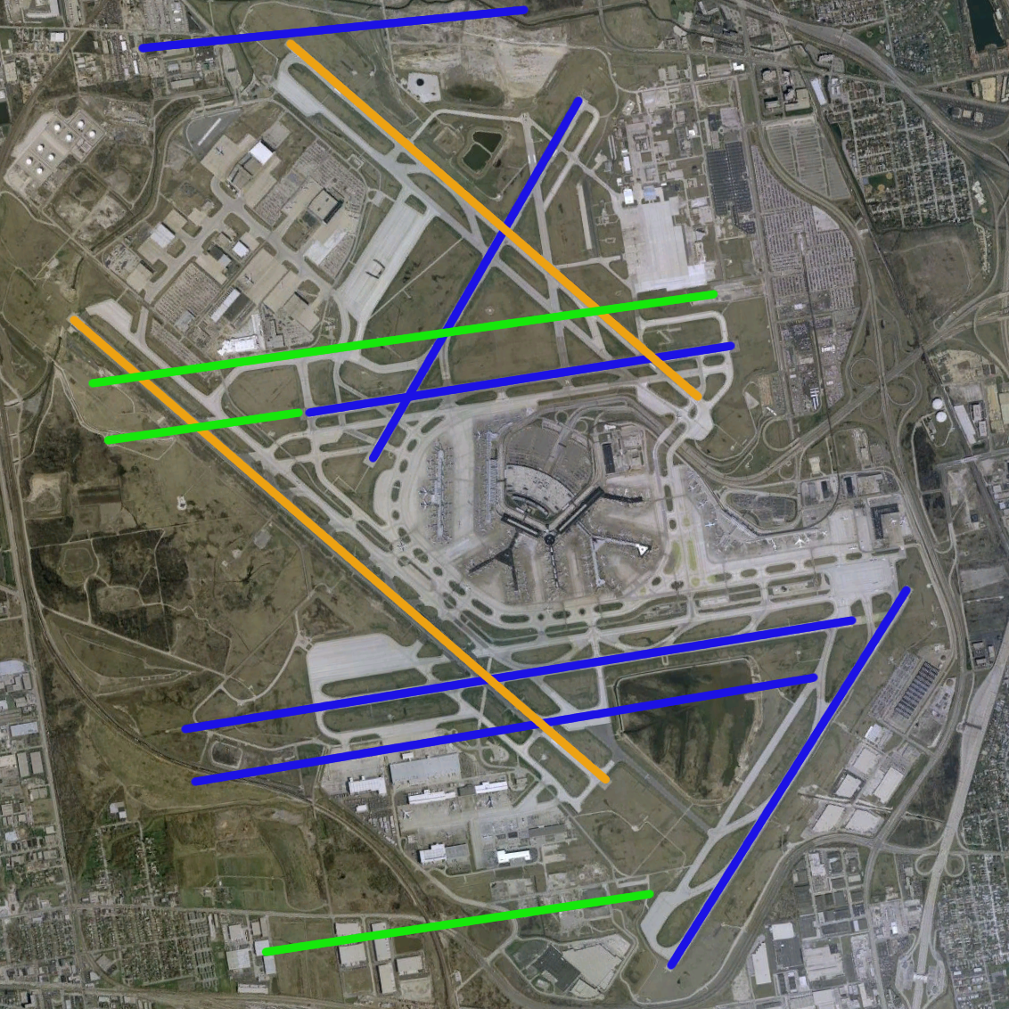
| คำอธิบาย | O'Hare International Airport modernization program - phase 3 runway configuration (blue = existing, green = new, orange = removed) | |||
| แหล่งที่มา | NASA World Wind Screenshot, USGS urban ortho; [1] | |||
| ผู้สร้างสรรค์ |
Runway overlay by User:Wangi |
|||
| เวอร์ชันอื่น | Image:O'Hare International Airport (USGS).png, Image:O'Hare International Airport (USGS) Current.png, Image:O'Hare International Airport (USGS) Phase1.png, Image:O'Hare International Airport (USGS) Phase2.png, Image:O'Hare International Airport (USGS) Final.png |
.png)
_Current.png)
_Phase1.png)
_Phase2.png)
_Final.png)
ประวัติไฟล์
คลิกวันที่/เวลาเพื่อดูไฟล์ที่ปรากฏในขณะนั้น
| วันที่/เวลา | รูปย่อ | ขนาด | ผู้ใช้ | ความเห็น | |
|---|---|---|---|---|---|
| ปัจจุบัน | 06:54, 19 กุมภาพันธ์ 2552 | | 1,132 × 1,132 (2.1 เมกะไบต์) | Mahahahaneapneap | Compressed |
| 04:49, 1 กรกฎาคม 2550 |  | 1,132 × 1,132 (2.12 เมกะไบต์) | Brianski | optimized, de-interlaced | |
| 16:58, 14 พฤษภาคม 2549 |  | 1,132 × 1,132 (2.55 เมกะไบต์) | Wangi | {{Information| |Description=O'Hare International Airport modernization program - phase 3 runway configuration (blue = existing, green = new, orange = removed) |Source=NASA World Wind Screenshot, USGS urban ortho; [http://egov.cityofchicago.org/city/we |
หน้าที่มีภาพนี้
หน้าต่อไปนี้ โยงมาที่ภาพนี้:
การใช้ไฟล์ข้ามโครงการ
วิกิอื่นต่อไปนี้ใช้ไฟล์นี้:
- การใช้บน de.wikipedia.org
- การใช้บน en.wikipedia.org
- การใช้บน fr.wikipedia.org
- การใช้บน id.wikipedia.org
- การใช้บน pl.wikipedia.org
- การใช้บน ru.wikipedia.org
- การใช้บน zh.wikipedia.org
_Phase3.png)