
ไฟล์:South China Sea vector.svg

ขนาดของตัวอย่าง PNG นี้ของไฟล์ SVG นี้: 637 × 600 พิกเซล ความละเอียดอื่น: 255 × 240 พิกเซล | 510 × 480 พิกเซล | 816 × 768 พิกเซล | 1,088 × 1,024 พิกเซล | 2,176 × 2,048 พิกเซล | 1,004 × 945 พิกเซล
ดูภาพที่มีความละเอียดสูงกว่า ((ไฟล์ SVG, 1,004 × 945 พิกเซล, ขนาดไฟล์: 657 กิโลไบต์))
| รูปภาพหรือไฟล์เสียงนี้ ต้นฉบับอยู่ที่ คอมมอนส์ รายละเอียดด้านล่าง เป็นข้อความที่แสดงผลจาก ไฟล์ต้นฉบับในคอมมอนส์
|
ความย่อ
| คำอธิบาย |
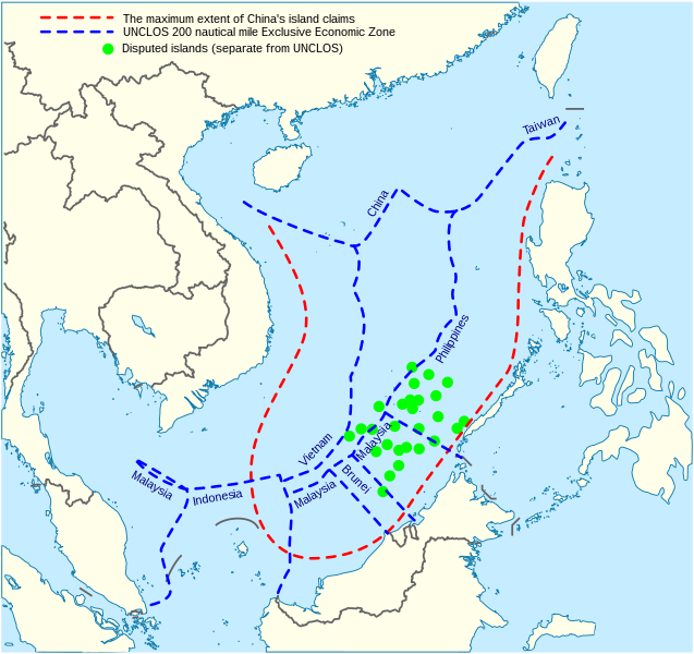
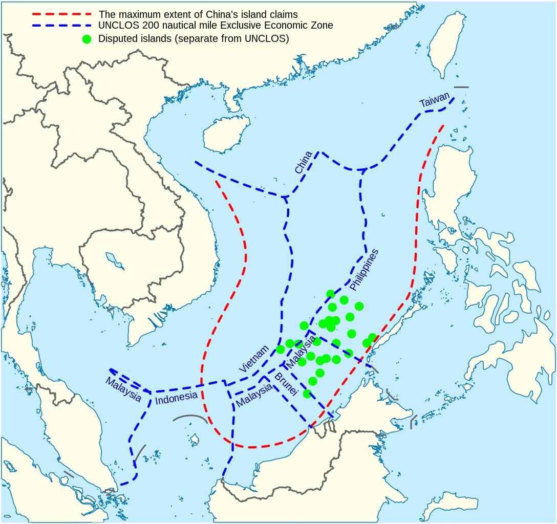
English: China's maritime claim (red) and UNCLOS exclusive economic zones (blue) in the South China Sea |
| วันที่ | |
| แหล่งที่มา |
งานของตัว |
| ผู้สร้างสรรค์ | Goran tek-en |
| SVG genesis | ซอร์สโค้ดของ SVG นี้ตรวจสอบถูกต้องแล้ว ไฟล์ภาพกราฟิกส์เวกเตอร์นี้ สร้างขึ้นโดยใช้ Inkscape |


การอนุญาตใช้สิทธิ
ไฟล์นี้อยู่ภายใต้สัญญาอนุญาต ครีเอทีฟคอมมอนส์ แบบแสดงที่มา-อนุญาตแบบเดียวกัน 4.0 นานาชาติ
การแสดงที่มา: Goran tek-en
- คุณสามารถ:
- ที่จะแบ่งปัน – ที่จะทำสำเนา แจกจ่าย และส่งงานดังกล่าวต่อไป
- ที่จะเรียบเรียงใหม่ – ที่จะดัดแปลงงานดังกล่าว
- ภายใต้เงื่อนไขต่อไปนี้:
- แสดงที่มา – คุณต้องให้เกียรติเจ้าของงานอย่างเหมาะสม โดยเพิ่มลิงก์ไปยังสัญญาอนุญาต และระบุหากมีการเปลี่ยนแปลง คุณอาจทำเช่นนี้ได้ในรูปแบบใดก็ได้ตามควร แต่ต้องไม่ใช่ในลักษณะที่แนะว่าผู้ให้อนุญาตสนับสนุนคุณหรือการใช้งานของคุณ
- อนุญาตแบบเดียวกัน – หากคุณดัดแปลง เปลี่ยนรูป หรือต่อเติมงานนี้ คุณต้องใช้สัญญาอนุญาตแบบเดียวกันหรือแบบที่เหมือนกับสัญญาอนุญาตที่ใช้กับงานนี้เท่านั้น
ประวัติไฟล์
คลิกวันที่/เวลาเพื่อดูไฟล์ที่ปรากฏในขณะนั้น
| วันที่/เวลา | รูปย่อ | ขนาด | ผู้ใช้ | ความเห็น | |
|---|---|---|---|---|---|
| ปัจจุบัน | 21:31, 15 กุมภาพันธ์ 2565 | | 1,004 × 945 (657 กิโลไบต์) | ماني | File uploaded using svgtranslate tool (https://svgtranslate.toolforge.org/). Added translation for fa. |
| 22:44, 16 พฤศจิกายน 2564 |  | 1,004 × 945 (651 กิโลไบต์) | Goran tek-en | ppi to 96, optimized, cleaned up | |
| 02:40, 10 พฤศจิกายน 2557 |  | 1,004 × 945 (729 กิโลไบต์) | Cmglee | Label UNCLOS regions. | |
| 06:15, 20 พฤษภาคม 2557 |  | 1,004 × 945 (723 กิโลไบต์) | Benlisquare | Fix misinformation, see en:Talk:Nine-dotted line. The red line represents the extent of China's island claims, and not sea territory claims. China's maritime territorial claims are based on distance from claimed islands, and are not demarcated by... | |
| 21:40, 23 มกราคม 2557 |  | 1,004 × 945 (722 กิโลไบต์) | Goran tek-en | User created page with UploadWizard |
หน้าที่มีภาพนี้
หน้าต่อไปนี้ โยงมาที่ภาพนี้:
การใช้ไฟล์ข้ามโครงการ
วิกิอื่นต่อไปนี้ใช้ไฟล์นี้:
- การใช้บน af.wikipedia.org
- การใช้บน cs.wikinews.org
- การใช้บน en.wikipedia.org
- การใช้บน fa.wikipedia.org
- การใช้บน fi.wikipedia.org
- การใช้บน fr.wikinews.org
- การใช้บน fr.wiktionary.org
- การใช้บน ja.wikipedia.org
- การใช้บน kk.wikipedia.org
- การใช้บน ko.wikipedia.org
- การใช้บน pl.wikipedia.org
- การใช้บน ru.wikipedia.org
- การใช้บน vi.wikipedia.org